


Introduction
General
As someone interested in ancient mysteries I purchased and read ‘The Atlantis Blueprint’ by Flem-Ath and Wilson shortly after it was published in the UK. One of the things that interested me was that Avebury was listed as one of the three ‘original sacred sites’ according to the theory the book proposes. The other two were Ur and Abydos.
Living as I do fairly close to Avebury I decided to pay the site a visit just for something to do on a Sunday. Flem-Ath also mentioned that some of his ‘sacred sites’ had indications within their layout or structure that made reference to the three previous polar positions of the Earth. These previous positions were those it has had over the past 100,000 years as theorised by Hapgood in his book ‘Path of the Poles’. It occurred to me to look at Avebury to see if there were any indications in the structure and layout of this nature. Flem-Ath made no reference in his book to visiting Avebury.
To be honest I had no expectation of finding anything. How wrong I was..
Atlantis Blueprint theory
For a full explanation and reasoning behind this theory the reader should of course obtain and read Wilson & Flem-Aths book. For relevance to the rest of this paper I will lay out the main points as follows.
Firstly, it is related to Hapgoods Polar displacement theory in which he lays out evidence that the Earth’s crust has slipped around causing the poles to move relative to the surface of the Earth but not relative to the Sun. This has caused different regions of the Earth surface to be glaciated at different times. Hapgood proposes there are no ‘Ice Ages’ as such. Simply that the movement of the pole causes different areas to be covered in Ice at different times. Also that this slippage can occur relatively quickly when it does happen. Possibly just measured in terms of a few years. He has evidence for three specific movements in the last 100,000 years and many others throughout geological time. He also proposes that these slippages cause catastrophic problems for flora and fauna in the regions nearer to the poles or those most affected by the particular slippage direction. Most recently he believes it contributed to the demise of the so called ‘mega fauna’, Mammoths etc in North America and Siberia some 12- 6,000 years ago.
Wilson & Flem-Ath think mantle displacement rather than crustal displacement is a more likely explanation and I have found several papers on the Geological society website that discuss mantle/core discontinuity so it is not anathema to modern scientific thinking.
Hapgood mentions as an aside in his book that some ancient maps appear to show the world as it would have looked prior to the last Polar displacement. He wrote a further book called ‘Maps of the ancient sea kings’ on this subject. The implication being that human knowledge and civilisation therefore predated the end of the last ‘Ice age’.
It was this implication that Wilson & Flem-Ath picked up on and expanded. They eventually concluded that there was an ancient worldwide civilisation. They were aware of previous polar displacements and how damaging they could be. They therefore, set up a series of measuring points around the world that were related to Giza and the Poles so they could measure if any slippage was taking place and take appropriate (evacuation?) action in the areas likely to be most effected.
These measuring points were at specific relative positions and the overall theory shows that many of these positions still have ancient monuments associated with them and further that it is possible to predict where other ancient monuments may be based on the knowledge of how these measuring points were set up. (Read the book for a full explanation!). These ancient monuments show characteristics that relate to previous poles. For example Wilson & Flem-Ath show that the Sphinx temple at Giza is misaligned to the mortuary temple of the great pyramid by 28 degrees. This bearing points to the previous North Pole. Also this temple has 28 pillars.
My task in the rest of this paper is to show the reader that similar evidence exists at Avebury to show that the builders had knowledge of the position of previous North Poles and this is demonstrable in the alignments of the Avebury monument structures and the bearings between them.
The Avebury prehistoric monuments
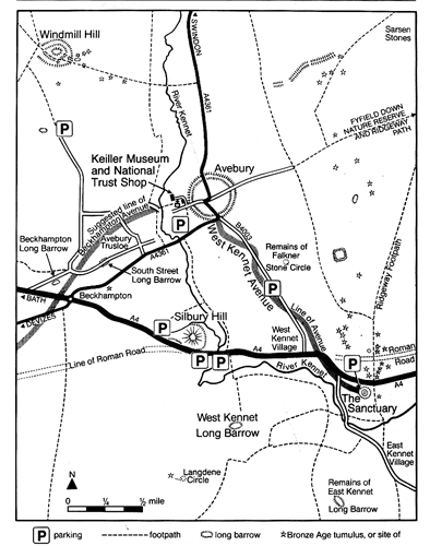
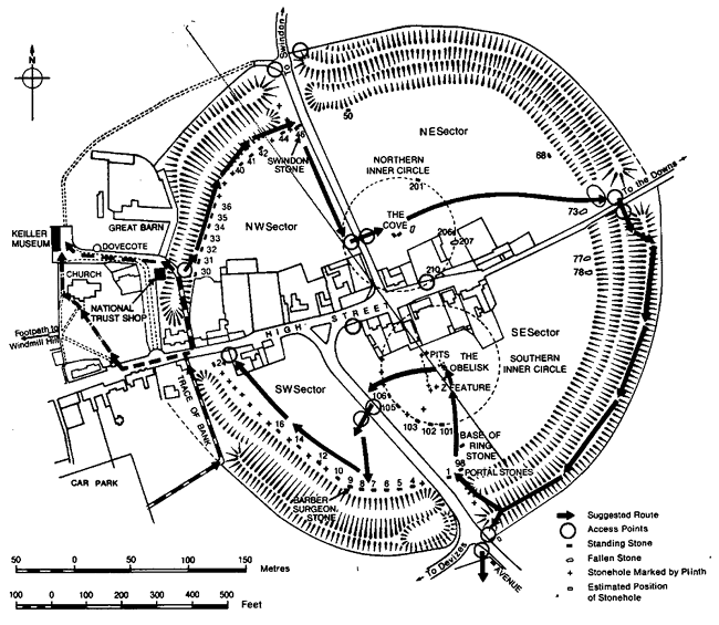
Avebury Monuments Map. Fig 1
The Avebury prehistoric monuments are situated in the county of Wiltshire in England. They are at 51 degrees north, 1.5 degrees west.
They consist of several main parts. There is the main Avebury bank/ditch and stone circle itself. There is Silbury hill about 2km to the south of the main circle. There is West Kennet long barrow a further 1 km south. East Kennet long barrow is about 2 km SE of West Kennet Long barrow. Windmill hill (a hill fort) is 3 km NW of Avebury and the Sanctuary is about 3km SE of Avebury. There are a plethora of other small barrows, standing stones and features within 5km radius of the centre of Avebury stone circle. See Fig 1 for a general map of the area.
Avebury Circle
According to conventional wisdom built circa 2600-2100 BC. Although the official English heritage guidebook does admit it is ‘undated by modern dating methods ..’.
It is the largest Henge monument in Britain. The main stone circle is approximately 175m in Radius with a large ditch and bank outside. It also contains two smaller circles inside (Each bigger than Stonehenge!) of about 50 m radius.
The whole monument has been extensively disturbed. Many stones were taken down and buried in the Middle Ages at the behest of the church who thought the structure pagan. Many stones were broken for building material throughout the 1600 – 1800’s. The village of Avebury has been built in the centre of the circle with several roads going through. The site was reconstructed in the 1930’s with those remaining stones repositioned as thought correct at the time. The main circle was thought to have 98 stones. All of many tonnes in weight and some of the remaining ‘portal’ stones around the 4 gateways are colossal. The ‘Swindon stone’ for example is estimated to be around 65 tonnes. The two inner rings were thought to have had 27 and 29 stones in. Although the northern inner ring of 27 stones also had three cove stones and the southern inner ring had a central stone called the obelisk which had been described at around 1720 but has since been broken up. Each inner ring complex therefore had 30 main stones. See Fig 2.

Avebury circle and ditch today. Fig 2
Silbury Hill
Silbury hill is the largest prehistoric man made mound in Europe. It is 39.5 m high. After two centuries of archaeological investigation its purpose is unknown. It is not a tomb. It is thought to date from 2660 BC. Internally it is a stepped circular pyramid. Originally built in chalk it would have gleamed white as would the Avebury bank and ditch.
West Kennet long barrow.
Thought to date from 3700 BC. It has been thoroughly investigated and consists of several north and south chambers in which burials were found. It was disturbed prior to scientific investigation. It is aligned East-West along its long axis.
The Sanctuary
Again dating from 3700 BC. It is connected to Avebury by a standing stone avenue that is now virtually entirely gone. This avenue is thought to date from ‘only’ 2300 BC. Some sort of circular timber building seems to have stood in the centre of a rough stone circle on the site. Purpose unknown.
Windmill Hill
This is thought to be the earliest feature of all the monuments but contemporary with West Kennet and the Sanctuary at about 3700 BC. It is thought to be the largest Neolithic causewayed camp ever found. Three concentric ring ditches enclose an area of about 8.5 ha.
East Kennet long barrow.
This feature appears not to have yet been scientifically investigated. No information about it appears in the English heritage leaflet on Avebury save for its position on the map.
Relationship of Avebury site to previous polar positions
Unavoidably this now has to get down to some number crunching. Distances and bearings have been worked out with the ‘How far is it?’ program available on the Internet. It works out the distance between and the bearing to and from two points on the Earth surface as given by their co-ordinates.
Previous Pole positions (Table 1)
|
Previous Pole (Abbrv) |
Current position |
Age Yrs before present |
Bearing from Avebury |
Distance from Avebury Km |
|
Yukon (YKP) |
63 N 135 W |
80,000 + |
22.5 NW |
6725 |
|
Greenland Sea (GSP) |
73 N 10 E |
50-80,000 |
8.8 NE |
2514 |
|
Hudson Bay (HBP) |
60 N 83 W |
12-50,000 |
45.5 NW |
4907 |
|
Current North Pole (CNP) |
90N 0 W |
0-12,000 |
90 N 0 W |
4339 |
This means that 80,000 years ago Avebury was tropical at about 30 degrees North. Between 50 and 80,000 years ago Avebury was within the Arctic Circle at 67 degrees North. Between 12 & 50,000 years ago Avebury was temperate at 48 degrees North. Finally between 12,000 years ago and the present Avebury was also temperate having not moved much at 51.5 degrees North.
Extent of previous polar displacements (Table 2)
|
Displacement From – To |
Distance of shift Km |
Percentage of Earth circumference. % |
|
YKP – GSP |
4687 |
11.7 |
|
GSP – HBP |
3891 |
9.7 |
|
HBP – CNP |
3347 |
8.4 |
Each Polar displacement seems to be roughly the same order of magnitude at about 10% of the earths circumference. Depending on the direction this can have dramatic effects on certain locations and hardly any effect at all on others. Avebury for example was moved from the latitude of the tropics to the arctic circle during the YKP to GSP displacement but hardly any latitude at all during the HBP – CNP displacement.
Alignments within the Avebury monuments that correlate with previous Pole positions
Whilst assimilating the information in this section bear in mind that previous Polar positions are estimates and that they are also a ‘moving target’ as the displacement periods are unknown.
Only alignments of the major monuments and one other major prehistoric site in Britain have been used. There is no need to ‘find’ some previously obscure feature and make something of it.
Also note that the bearings of the ‘how far is it?’ program have been calculated from positions input to the nearest degree. My readings of bearings between the Avebury monuments are accurate to a few of degrees and also dependent on the accuracy of the map in the English heritage guidebook. If these monuments were being used as ‘sighting markers’ to detect Polar shift then absolute accuracy is not necessary. A few degrees of displacement will not change the climate of an area. 30 degrees of displacement will! It is 30+ degrees displacements that have occurred previously.
(10% displacement of Earth circumference = 36 degrees displacement)
Avebury circle itself
The first thing that strikes the visitor about the main Avebury ditch/bank/circle is that it has four clear entrances that are broadly laid out North, South, East and West. (See Fig 2).
However, it is also obvious that there is a significant misalignment to North/South. To the best of my accuracy and given that the entrances to the site have been extensively disturbed by roads being dug through I estimate the misalignment at 23 degrees west of north. No significance seems to be attached to this misalignment in either the English heritage guidebook or a book called ‘The secrets of the Avebury stones’ by T.Meaden.
This is because there is no obvious significance in astronomic terms or local geographic terms. However, the reader might have already noticed the significance in relation to previous Polar displacement. 23 degrees NW points almost exactly at the old Yukon Pole. (Bearing from Avebury 22.5 NW from table 1 above).
West Kennet long barrow
West Kennet long barrow is laid out East – West along its long axis. Although it is also noticeably misaligned. A right angle to its long axis also points 23 degrees west of north. It too is pointing at the Yukon Pole just as Avebury circle is.
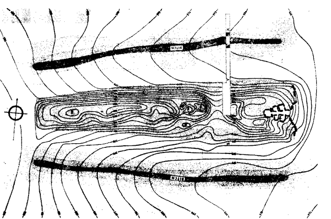
Plan of West Kennet Long Barrow. Fig 3
East Kennet long barrow to Avebury
A bearing of East Kennet long barrow to the centre of Avebury is also pointing 23 degrees west of north. This line points at the Yukon pole. It may also be that the barrow itself is aligned in that direction. The rough plan in the English heritage guidebook indicates it might be. Some further work is required to confirm this.
Silbury Hill to Avebury
A bearing from Silbury hill to the centre of Avebury is 8 degrees East of North. This is almost exactly the estimate of the bearing of the Greenland Sea pole from Avebury at 8.8 degrees East of North from table 1 above.
In other words the line from Silbury to the centre of Avebury points exactly at the Greenland Sea pole. I believe this may be the first specific explanation of the possible purpose of Silbury hill ever proposed.
Avebury to Windmill Hill
The bearing from Avebury to Windmill hill is 46 degrees NW. From table 1 above this is almost exactly the estimated bearing to the Hudson Bay pole at 45.5 NW.
A line between Avebury and Windmill hill points at the Hudson Bay pole.
West Kennet long barrow – Silbury Hill – Windmill hill
West Kennet long barrow, Silbury hill and Windmill hill are three points on the same line. This line runs 26 degrees west of north. Again, very close to the bearing of the Yukon Pole at 22.5 degrees NW.
The Sanctuary – Avebury – Windmill Hill
A line from the Sanctuary, through the west gate of the Avebury circle to Windmill hill is straight. It bears about 44 degrees west of north. Again, very close to the estimated bearing of the Hudson Bay pole at 45.5 degrees NW.
Avebury centre – North East inner ring centre.
The centre of Avebury circle and the centres of the inner rings can only be estimated due to the extensive disturbance of the site. However, a best guess bearing gives 11 degrees east of north. Again, very close to the 8.8 east of north towards the Greenland Sea pole.
The NE and SE Inner rings
A line between the estimated centre points of the NE and SE inner rings is nearly parallel to the estimate of the misalignment of the whole Avebury circle at 23 degrees west of north. This line also points to the Yukon Pole.
Another interesting coincidence lies in the number of Stones used in these inner rings. Wilson & Flem-Ath note that some ‘sacred sites’ are the same degrees from the equator as there are between bearings from them to two different poles. Canterbury is a 45/45 site on this basis relative to its latitude now and the angle between its bearing from current north and Hudson Bay north. It was noted that the Sphinx temple was a 28/28 site based on previous latitudes and bearings and that the number 28 crops up in numbers of pillars, steps etc on the site.
At Avebury it was a 30-degree north site during the Yukon pole and also the bearing between the YKP and the next pole in the Greenland Sea is estimated at about 30 degrees when viewed from Avebury. So Avebury is a 30/30 site in that context.
The two inner ring complexes at Avebury each contained 30 stones. (See above).
How much of a coincidence is it that the exact number 30 crops up twice in the construction of the Avebury monument?
Avebury to Dowth Henge
So far nine different indications of previous polar positions have been found from the alignments within and between the monuments of the Avebury complex. One more is of interest. I read somewhere that the distance between Avebury and one of the largest henge monuments in Ireland is exactly 1 % of the Earths circumference. I decided to check it’s bearing as well.
Dowth henge is near Dublin in Eire and when I checked it’s bearing from Avebury I found it to be 47 degrees west of north. Again, within two degrees of pointing at the estimated position of the Hudson Bay pole.
I did also check in the other direction which would be somewhere in northern France but currently have no suitable map. A further piece of work will be to investigate if there are any ancient monuments approximately 400 km SE of Avebury on the reverse bearing.
While I was looking at this I did notice on a map of Europe that there is a very good line from Cairo (Giza) through Rome, Geneva, Paris, London and Dublin that would then run on to the estimated position of the Hudson Bay pole. Further investigation of the significance of this (if any) will have to wait for another time, as it is not within the scope of this paper.
Discussion & Conclusion
So what does it all mean?
Firstly, what are the chances that it is all just coincidence? Well, quite low I think. I have only been interested in three bearings. To the nearest degree that is 3 out of 180 so there is only 1 in 60 chance that any alignment bearing I find will relate to one that I am interested in. However, some bearings I found were out by a few degrees. Allowing +/- 3 as a margin for error that would mean 18 out of 180 bearings were of significance to me. Still only a 1 in 10 chance of a positive result.
Nine bearings were found close to predicted bearings. A chance of 1 in 109 ?
Several of the alignments are very, very close to predicted bearings. That of Avebury circle itself and West Kennet long barrow itself. These monuments are aligned to the Old Yukon pole directly without even needing to find something else to line up with.
Of the others, Silbury to Avebury, Avebury to Windmill and East Kennet to Avebury are all extremely close to a predicted bearing. The fact that Silbury to Avebury would come up within a degree of a predicted bearing at a 1 in 60 chance seems particularly significant as these two are the most visible monuments of the whole complex.
This investigation was started to test the Wilson/Flem-Ath hypothesis or observation that ancient monuments that are relevant to their Atlantis blueprint theory will have alignments or constructions that correlate with previous polar positions and the previous co-ordinates those locations had. In the case of the Avebury monuments it has been shown that there is a lot of evidence that would support this theory.
The fact that the Avebury monuments encapsulate this ancient knowledge does not necessarily mean that they are themselves that old. There is however, a long tradition of sacred sites being taken over by successive generations for their own use. Pagan temples that became Roman temples that became Christian churches for example. It may be that the ancient sighting posts used to pre warn the old civilisation of Polar displacement have been re-used centuries later but that some of the original alignments were maintained out of respect (or fear!).
I believe this paper is the first to propose the nature of a specific relationship between the main Avebury monuments other than the fact that they seem to be contemporary in age. There are other theories on the use of the Avebury circle. Meaden’s view is it is about fertility. Of course this could be the later culture re-interpreting Avebury in their own terms. As I noted earlier there is no explanation for the misalignment of the main circle in this theory, nor is there any explanation of Silbury Hill and the significance of the relative positions of the other monuments.
In conclusion, my theory is that the Avebury monuments were once a Polar displacement measuring station of some sort.
Copyright © S. F. Wells December 2003