


Please welcome for January 2012 Author of the Month David Warner Mathisen, author of The Mathisen Corollary, a book which explores how a specific catastrophic flood theory may have important implications for a wide range of mysteries about mankind’s ancient past. David is a graduate of the United States Military Academy at West Point, the United States Army’s Ranger School, and Texas A&M University, where he earned a Masters degree in Literature prior to returning to teach at the Academy.
He believes that good analysis is critically important, whether analyzing a tactical situation, a work of literature, a crime scene, a potential investment, or the geological features in the world around us.www.davidmathisen.com
Thank you for having me — it’s a real privilege to have the opportunity to share my work on this forum. Graham Hancock has obviously done a tremendous amount to illuminate huge portions of human history and human experience which have been overlooked or deliberately ignored by the academic world in recent times, and his ongoing efforts are an inspiration to everyone who realizes that the conventional storyline is leaving something out and who wish to know the truth (or at least bring us closer to the truth rather than further and further away from it).
His introduction in the “Forum” section of this website, in which he states that he wants to create a space that is “not exclusively a Graham Hancock site, but a place where ideas and perspectives on the past can be put forward and discussed by other writers and researchers as well — and indeed by anyone with something interesting to say and the ability to say it” is gracious and commendable, because it really seems pretty clear that the unraveling of the mystery will take a lot of different people with lots of different gifts and talents and life experiences all working together, sharpening and challenging one another’s thoughts and theories, and bringing different perspectives to bear on the questions, and I’m looking forward to sharing in that conversation.
You, dear fellow-reader and fellow-contributor to this discussion, are also to be commended, because you are taking the time to wrestle with and add your perspectives and insights regarding what really is a critically important subject, a subject which – although it often deals with mankind’s most ancient past – is vitally important to where we find ourselves at this moment in history, and vitally important to the future of mankind. Although it probably seems to you (as it does to me) that one could hardly avoid being interested in such a subject matter, in fact some people still are unaware of the gaping holes in the conventional theories, and live their lives without realizing that evidence such as that discussed in this site and in the books and work of “alternative theorists” even exists.
We can hope that they themselves will become engaged with this question and offer their own analysis in the future, but in the meantime, you are to be commended for looking beyond the first explanation or theory that is offered to explain any given piece of evidence, and considering whether there might perhaps be other explanations which would provide a more satisfactory answer for the clues that we see all around us. In my own writing, I use as an analogy the example of Sherlock Holmes or even the gang from the old Scooby Doo cartoons, who invariably arrive at a crime scene to find that the authorities have a theory and that those authorities are quite certain that their theory is the last word on the matter. They usually find that the authorities are quite unwilling to have their thesis challenged, especially by outsiders. However, it is very often the outsiders who are able to see that there could be another explanation, because the outsider or outsiders are coming from a completely different perspective, and also because they do not have an institutional bias the way “the authorities” (no matter how competent or how well-meaning) often develop institutional bias simply by virtue of their role and position within the structure of society. There is certainly a lesson to be extracted from the fact that in almost every one of the most beloved stories within the crime and mystery genre, the hero (or heroine, or even dog, in the case of Scooby Doo) who ends up solving the case is a marginalized figure who operates on the fringes of society and who isn’t taken seriously by those in authority.
In that spirit of open-minded examination of alternative explanations for the clues of the case, then, I would like to suggest that there is a theory which has not really been heard from yet, and a theory which may not prove to be too popular even among those who are used to examining alternative theories, but a theory which (in my analysis at least) does a really outstanding job of explaining a whole lot of evidence – even some of the most puzzling evidence of which Graham Hancock readers are keenly aware, such as underwater ruins at great depths, fossil evidence of heavy forests in locations currently near the Arctic and Antarctic Circles, or even the worldwide evidence of extremely ancient understanding of sophisticated concepts such as the precession of the equinoxes or the mathematical concepts of phi and pi. That alternative explanation which I believe so elegantly suits this data is a theory that involves a cataclysmic global flood within human memory – an explanation many will oppose simply because it was the dominant explanation for so many centuries, and therefore carries a lot of historic and emotional baggage. But, like the authorities in the Sherlock Holmes or Scooby Doo crime story (who miss clues because of their own baggage), we would do well to let go of whatever predispositions we might bring along with us as we examine this evidence, and see whether setting down our own baggage and considering a different storyline might help us to solve the mystery.
Since the time of geologists James Hutton (1726 – 1797) and Charles Lyell (1797 – 1875), the dominant conventional paradigm for explaining the features we find on earth’s surface has been what geologists sometimes label as “uniformitarianism”: the idea that everyday processes such as those we see operating today, plus massive amounts of time, rather than extraordinary or catastrophic processes, are sufficient to explain the mountains, canyons, and even ocean trenches of our globe. Plate tectonics, proposed most notably by Alfred Wegener (1880 – 1930) and ridiculed harshly for many decades before it was accepted, continues in the uniformitarian tradition, by proposing tiny amounts of drift each year, which — given enough time – will be enough to push up mountains or form deep submarine trenches, and so forth. Today, tectonics is taught as though it is “proven science.” However, there is a tremendous amount of geological evidence which indicates that there may be some serious problems with the plate tectonic theory, so much evidence that it is worth asking whether there might not be an alternative which would explain the evidence better than tectonics can (the answer has a tremendous bearing on the mysteries of mankind’s ancient past as well, as we will discuss).
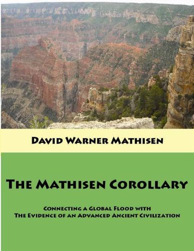
I discuss this tectonics-defying evidence in my book, and on a blog where I write on subjects relating to those discussed in my book. Some of this evidence includes the Arctic and Antarctic fossil evidence mentioned above, the arc-and-cusp shape of many Pacific trenches (very difficult to explain using the mechanics of drifting and diving plates), the prevalence of earthquakes far from supposed plate boundaries, the unexpectedly low gravity readings found over ocean trenches (which should actually have excess mass and excess gravity if the tectonic mechanism is correct), the incredible submarine canyons (not trenches) such as the Ganges Fan and the Indus Fan and the Monterey Canyon, the extraordinary sediment deposits stretching along the southern flanks of the Himalayas from Pakistan to Bhutan thousands of feet deep, and of course the evidence found in that superlative open-air geological laboratory the Grand Canyon.
If you follow the links above, you will find that all of these examples are geological clues discussed by Dr. Walt Brown, a graduate of West Point and of MIT, who has proposed a new global flood theory called the hydroplate theory, which he backs with extensive research and discussion of the principles of physics and chemistry and with literally hundreds of geological examples from around the globe, including those mentioned above and many others. The more I learned of his theory, which deals primarily with geology and geological evidence, the more I became aware that it could shed light on many of the mysteries of mankind’s ancient past as well. These geological and civilizational questions are clearly connected – it is no accident that those who seek to explain lost advanced civilizations eventually become aware of the mysteries surrounding Antarctica, and of alternative theories which in the past have been proposed to solve some of these mysteries, such as the earth-crust displacement theory, or the various Venus-collision theories. Geological theory is intertwined with theories of mankind’s ancient past, as we will discuss further below.
Dr. Brown’s hydroplate theory begins with one assumption – that there was once a large amount of water trapped under the earth’s surface. This water was under tremendous pressure (due to the weight of the crust above it) and when a rupture took place which enabled it to burst out, the results were catastrophic. The high-pressure water rushed out with tremendous violence, and the crack of the initial rupture spread rapidly in both directions until it encircled the globe and intersected itself again. The force of the escaping water eroded the crust above it and widened the crack on either side as it blasted away earth from the sides of the rupture, mixing massive amounts of sediments into the water that would eventually blanket the earth, and also removing the weight of the crust along the line of the rupture (which now encircled the earth “like the seam of a baseball,” in Dr. Brown’s words). The removal of so much sediment allowed the basement rock that had been below the line of the rupture to spring upwards, and this caused the massive plates that would become our continents (the now-separated pieces of the crust on either side of the rupture) to begin sliding away from the upward-springing seam in either direction, still lubricated by the escaping water beneath.
This upward-springing action on one end of the globe, however, would not just cause an “air bubble” to open up in the center of the earth, of course: instead, it would cause an equal and opposite “downward-sucking” action on the opposite side of the earth. This process created the Pacific basin, which contains geological features consistent with what you will see if you suck the air out of a metal gasoline can, for instance (creating a suction and a collapse), or if you stick your thumb into the side of a ping-pong ball (there wasn’t a thumb pressed into the Pacific because it wasn’t pressed from above, it was pulled from beneath, but the arc-and-cusp shape of the Pacific trenches, and the fact that they lack the mass that they should have if they were indeed formed by one enormous plate subducting below another, indicates that the Pacific was formed by forces with similar vectors). The continents slid towards the Pacific basin and away from the upward-bulging mid-Atlantic ridge, their steep-sided continental shelves still matching the line of the mid-Atlantic ridge, because that was the line of the original rupture, whose upward-jetting water created the vertical sides of those shelves when the water that had been below the continents escaped.
Eventually, friction (as the subterranean water all escaped) or collision caused these sliding “hydroplates” to grind to a violent stop, creating violent buckling and long parallel mountain ridges roughly perpendicular to the direction of travel, just as you would create “mountains” in the front of your car if you drove it at high speed into a concrete wall. Also, along their forward edges especially, friction melted rock and created magma, which is why the “ring of fire” generally outlines the Pacific basin towards which all these plates were sliding. The thickening of the continents due to this buckling caused the waters to begin to rush off into the ocean basins, although in many places it was trapped and lifted to great elevations as the hydroplates came to a stop. Later, when precipitation continued to fill these trapped bodies of water, some of them breached violently, carving features such as the Grand Canyon (the Vale of Kashmir may have been another example, and the Jhelum River may mark its breach). In other parts of the world, where trapped bodies of water received less precipitation, the inland seas sometimes dried up or receded over the centuries (the Great Salt Lake in Utah may be one such example, and Lake Titicaca in the Andes may be another, although it has not dried up completely but only receded significantly).
Not only does this theory explain the same geological features which the plate tectonic theory tries to explain, and does it in a way which explains geological mysteries that tectonics has difficulties explaining, but it also appears to throw light on many mysterious aspects of mankind’s ancient past. For example, it is no doubt well-known to readers of this website that many ancient monuments are very precisely aligned with celestial phenomena (such as the rise or transit of important stars or constellations), solar stations (such as the rising or setting of the sun on the equinoxes, solstices, or cross-quarter days), and occasionally with significant points on the lunar cycle, or with the cardinal directions (the Great Pyramid being a notable example of alignment with cardinal directions as well as with celestial phenomena). Many of these ancient monuments are thousands of years old. If the theory of plate tectonics is correct, proposing as it does that continental plates often move an inch a year (sometimes more, sometimes less), how is it possible that any of these alignments are still intact? At an inch a year, the Great Pyramid, Stonehenge, and the megalithic temples on Malta would have drifted hundreds of feet, and yet all of them still display astronomical alignments, solar alignments, cardinal direction alignments, or a combination of the above. The hydroplate theory argues that the plates did slide, but that they did so once, and that they are no longer drifting about the way the tectonic theory says they are. They do continue to shift on occasion (which is one cause of earthquakes, especially in those areas next to the Pacific basin), but they do not drift. The monuments mentioned above, of course, were built after the cataclysmic flood, and hence supporters of the hydroplate theory are not surprised that they are still aligned.
This question of the ongoing alignments of ancient monuments is just one example of the intersection of geological theory and ancient human history, and an example of the importance of examining the two in conjunction with one another, because they are intimately connected. Another example is the explanation of the sedimentary layers found around the globe. Conventional theory holds that these were laid down over hundreds of millions of years, but the hydroplate theory argues that they were laid down during the flood event. In fact, many geological features seem to indicate that these layers were all soft and pliable when force was applied to create buckling or folding of these layers, which is consistent with the hydroplate theory and not with a theory of millions of years (in which case the layers would be brittle and would not exhibit the graceful curves and folds seen in many places on earth). Of course, if the strata were all laid down during the flood event, then the assumption that fossils (including human fossils) found in certain layers must be extremely old may well be completely incorrect. Strangely, even alternative researchers who reject the conventional explanations typically assume that human fossils or artifacts found in strata associated with great age are evidence that modern humans have been around for hundreds of millions of years, instead of considering the possibility that perhaps the strata are younger than the conventional theorists assume.
The hydroplate theory argues that the thickening of the continental plates at the end of the flood (when they ground to a halt) could have altered the rotational alignment of the earth. By far the thickest of the continents is found in the region of the Himalayas, home to the highest mountains on the globe. If this region was formed rapidly during a catastrophic event (as the hydroplate theory argues that it was), it would have acted like a big lead weight slapped onto the side of the spinning earth. The laws of physics would argue that this weight would want to move towards the equator by the principle of centrifugal force (if you spin a weight on a string around your head, it will naturally want to spin straight outwards). The Himalayas would have pulled towards the equator, but the bulge of the earth’s extra mass at the equator (the “spare tire” of mass at the equator, also caused by centrifugal force) would have acted to counterbalance this motion, and a kind of “tug-of-war” would have ensued. It was a tug-of-war which the larger equatorial bulge would have ultimately won, but not without a compromise, and in the process the entire earth would have rotated as much as 35o to 45o, moving the areas that were formerly at the poles to new latitudes, and swinging land that had been in temperate latitudes up to the Arctic and down to the Antarctic. This side-effect of the global flood would explain the anomalous fossils of the far north and far south, and it would also explain the submarine feature at the bottom of the Indian Ocean known as Ninety East Ridge, which points generally towards the Himalayas and which is an important supporting piece of evidence for this aspect of the theory.
The preponderance of legends, legends, and sacred writings around the world appear to preserve knowledge of such a flood, indicating that (as difficult as it may be to believe for some) this catastrophe may have taken place within human memory. Interestingly enough, many of these ancient texts speak of the floodwaters coming up from under the earth, consistent with the hydroplate theory (Genesis of course speaks of the “waters under the earth” and the “fountains of the great deep,” and the book of Job speaks of it breaking forth as if it had “issued out of the womb,” but other traditions seem to maintain similar memories, such as the legends of the Cuna people of Central America – modern Panama – who spoke of the flood as being due to great jars of the underworld being broken up by a god).
If human beings were present during the rotation of the entire globe that took place as one consequence of that flood (due to the formation of the Himalayas and their impact described above), then it would certainly have radically altered the view of the heavens and the constellations, putting an entirely different set of stars along the line of the ecliptic. Many who study alternative theories for mankind’s ancient past are aware that myths and legends from around the world indicate a connection between the “chopping down of the axis” of heaven and the initiation of the flood – Giorgio de Santillana and Hertha von Dechend discuss much of this evidence in their indispensable 1969 text Hamlet’s Mill: an essay on myth and the frame of time. My book discusses that and other mythological evidence of a connection between the two events.
The unhinging of the axis of heaven, of course, is also connected with the phenomenon of precession. If the earth did indeed experience a “Big Roll” during human memory, then the constellations on the ecliptic that enable us to perceive the effects of precession would have changed (to the now-familiar zodiac constellations we have today). It is certainly likely that those who lived through that event and afterwards would have paid great attention to the new markers of the celestial phenomena and it may explain why they were so careful to preserve their knowledge of it in myth and monument. It is certain that myths around the world describe this great unhinging of the axis as something that took place at a distinct point in time (often due to the chopping down of a tree by a god or a hero) and never as “the way things have always been.”
Of course, the conventional timeline of human history does not allow for the possibility that mankind was capable of understanding sophisticated processes such as precession at the early dates that myth and monument indicate that they understood it. Again, the connection between geological theory and theories of mankind’s ancient history is evident. The conventional view posits long geological ages, a view which corresponds to a vision of biological life that moves slowly but steadily from very primitive to more and more complex and advanced. Anthropologically, this view proposes “early humans” which are not far removed from apes, who then become more and more modern, eventually arriving at modern humans who still behave in very primitive hunter-gatherer fashion for well over a hundred thousand years before discovering the benefits of agriculture and then settling down into villages which evolve into the first cities.
Like the conventional view of geology, this timeline of human history may be widely accepted, but it does not comport well with the evidence. What we find instead is evidence of extremely advanced scientific understanding as far back in human history as it is possible to see. Not only do we find evidence of precisely aligned megalithic structures, some of them with impressively joined stones of enormous size, but we also find evidence in both monument and myth of an understanding of astronomical concepts such as the precession of the equinoxes. Precession is a very subtle phenomenon: it takes 71.6 years to perceive even one degree of difference in the position of a star when the earth is at its exact same location in its orbit. To arrive at the understanding of precession, then, requires the ability to know when the earth is at its exact same location on its annual circuit from one year to the next. On top of that, it requires the ability to measure the location of stars and the ability to record their location accurately. It then requires accurate records for longer than a single human lifetime (because the motion is so slow that it only makes one degree of change in a span that is about as long as a human lifetime). Finally, it requires the analytical skill to observe that the records demonstrate this motion, a very subtle motion, and then the analytical skill to create a framework to explain that motion. These are not skills that hunter-gatherer societies would be expected to have the time or the resources or even the inclination or need to develop, and yet the very earliest civilizations of whom we have evidence have each left irrefutable evidence that they not only knew about precession but understood it at a very high level of sophistication.
Conventional history does not admit knowledge of precession until the time of Hipparchus of Nicea (c. 190 BC – c. 120 BC), whose work set the stage for Ptolemy (c. AD 90 – c. AD 168). Neither of these relatively late astronomers, however, came anywhere close to the actual constant of precession (which is one degree every 71.6 years) but instead appear to have fixed a lower limit (no slower than one degree every 100 years, with an indication that the actual rate was probably faster than that, but which they were not able to nail down with any greater precision). What, then, are we to make of the fact that the mythology and architecture of people who lived many thousands of years before Ptolemy and Hipparchus demonstrate knowledge of a constant of precession that is quite precise: one degree every 72 years? This and other evidence familiar to readers of Graham Hancock and other authors points to the conclusion that the ancient history of mankind was actually much different from the simplistic timeline that is taught in schools to this day.
One reason that catastrophic theories such as those involving a global flood are so threatening to the defenders of the conventional timeline is that these catastrophic theories threaten conventional frameworks of human history and even Darwinian biology (which has become something of a religious tenet in the past one hundred years). If we subscribe to a theory which requires millions of years to carve the Grand Canyon, then we can also support theories in which biological species evolve into their present forms over millions of years, and in which mankind follows a long but generally unbroken line from primitive ignorance to modern sophistication. This storyline is immensely comforting to many (it places us at the pinnacle of history, for one thing, and makes continued progress seem like our natural birthright and something we need not fear will ever be interrupted).
If, on the other hand, a theory demonstrates that the Grand Canyon could have been carved in a few weeks or months, and what’s more demonstrates that such an explanation appears to fit the available evidence much more convincingly than does the theory of an ordinary river acting gradually for millions of years, then this sucks the wind out of the sails of an awful lot of other theories.
First of all, the possibility that the Grand Canyon could be carved in months means that, for all we know, the Grand Canyon could have been carved just a few months ago! Of course, since we have human record of its existence before that, we know that it wasn’t carved just a few months ago, but prior to human record of its existence, all bets are off. In fact, as Dr. Brown has pointed out, we have Native American oral tradition which asserts that it was carved during human memory, and so while we can say that the Grand Canyon may be several thousands of years old, we don’t have any real evidence leading to the conclusion that it is really millions of years old (the main reason for that conclusion is the assumption that it would take that long to carve it). If features on earth were carved only several thousands of years ago, then a major foundational support for Darwinian evolution is dramatically undermined. If canyons and mountain ranges were thrust up relatively recently, then that undermines the argument that bighorn sheep or mountain goats “adapted” to such environments (evolved the structures that enable them to hop around on cliff walls or mountain precipices) via natural selection over millions of years.
Such a theory of catastrophism also undermines the long ages of proposed primitive development for early humans. If there was a global flood within the past several thousand years, and if we have evidence demonstrating extremely advanced human knowledge and understanding several thousand years ago (evidence such as pyramids corresponding proportionally to the size of the spherical earth, or stone circles which increase by a factor of phi from one circle to the next), then we might conclude that, whatever the timeline looked like before the flood, those who lived almost immediately following the flood were already extremely advanced. In fact, they were so advanced that it is only possible to describe the civilizations that came after them as woefully ignorant. There is evidence that we may only now be reaching some of the same levels of technical skill in some areas, and in some areas of human knowledge we may still be ignorant of subjects which were well understood by those ancients. This timeline is dramatically different (and far less comforting) than the myth of constant progress (with “modern space-age man” at the pinnacle).
In fact, if the true history of mankind is anything close to the alternative view that these glimpses suggest, then it raises an extremely urgent question, and one which should concern everyone who cares about human civilization:
WHAT HAPPENED?
If mankind possessed such knowledge, and shared it around the globe, with contact between people on every continent, and apparent harmony or at least mutually beneficial trade taking place between members of all the different nations and families of the human race (who, after all, are all truly brothers and sisters, mutually descended from the survivors of a fairly recent global catastrophe, regardless of the physical and cultural differences that began to develop as they spread out again to inhabit the various parts of the planet), then what could have taken place to plunge them into ignorance, isolation, and hatred for centuries or even millennia to come?
We don’t know the answer, but it is pretty certain that if we don’t even know that it ever happened, we won’t be able to even start asking the questions.
The answer may or may not involve some of the suggestions and conclusions that I have reached in my book. The geological answers may or may not match exactly some of the conclusions Dr. Brown has reached with his extensive and rigorous examination of the evidence. But it is pretty clear that this is an important line of inquiry, and one that concerns everyone. We need to approach it with open minds, and with a willingness to entertain all possible explanations which can demonstrate that they can provide answers to the evidence.
That is why this forum and those like it are so important, and why the engaged analysis of all of its readers is so valuable. It is also why the thought leadership that Graham Hancock has demonstrated for more than two decades has been so exemplary and so important, and why the conversations that he has started around the world matter very much.
I am excited to be part of this conversation and urge everyone to stay engaged and not to become discouraged by those who use ridicule or derisive labels to shut down inquiry. I look forward to hearing what you have to say.
Star Myths of the World

Star Myths of the World

Star Myths of the World

The Mathisen Corollary

The Undying Stars

Astrotheology for Life
