


Following up his discovery that Schöner had mistakenly reproduced an ancient world map to depict the Antarctic continent on his 1515 world globe by matching geographical features to contemporary discoveries, the author attempts to verify adherence to the same methodology on Schöner’s 1524 globe. In the process the author discovers that Schöner has aligned a feature corresponding to Antarctica’s Atka Bay to a southward branching bay in Magellan’s recently discovered strait while also including accurate portrayals of Antarctica’s Siple and Carney Islands aligned to one of Magellan’s lesser known discoveries. Further, these newly incorporated features far more closely resemble their Antarctic counterparts than the actual discoveries, suggesting that Schöner was indeed implementing the same methodology as his previous globe by force fitting an ancient authentic map of Antarctica onto his 1524 globe to represent Magellan’s two lone discoveries.
Antarctica as depicted on Schöner’s 1524 Globe demonstrates a marked departure from his earlier version of the continent. It is possible that nine years after using Agrippa’s Orbis Terrarum as his template, Schöner suddenly realized his folly, but there is strong evidence to suggest that he actually abandoned the design in favor of one which better fit more recent geographical finds. Where his earlier maps of 1515 and 1520 were based on a 1508 expedition heralding a nonexistent strait, his 1524 map followed on the heels of a more recent expedition, the voyage of Ferdinand Magellan.
In his search for a passage to the Pacific, Magellan had spent months exploring various waterways along the South American coast. Entering each potential throughway with hope and high expectation and exiting with disappointment, but on October 21, 1520 he would finally enter the one waterway that would not disappoint. Yet midway into his prized strait, Magellan found the waterway breaking off into two directions. Antonio Pigafetta, an Italian scholar who accompanied Magellan and maintained the most extensive account of the voyage, states that the mouth of one waterway had lain toward the southwest and the other toward southeast (Fig. 1). Magellan sent two ships, the San Antonio and the Concepción, into the southeast waterway which was composed of Inútil Bay and Canal Whiteside, but only the Concepción returned and with news that this was a closed waterway lacking passage to the Pacific.
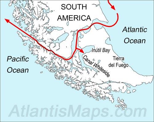
Figure 1 – Magellan’s route through the strait. Note the fork in the waterway halfway through. Magellan sent two of his ships in to explore the waterway now known as Inútil Bay and Canal Whiteside. Only one of the two ships, the Conception, returned and reported that this was a closed waterway lacking passage to the Pacific.
This closed waterway or bay extending off the strait was a new feature which Schöner’s previous designs did not account for. This seems to have been enough to prompt Schöner into reviewing other available options. Adhering to the previously established methodology, we can assume that once again he returned to rummaging through a collection of antiquated maps in various states of completion and wear, this time looking for a landmass bearing a bay with a particular shape, a design carried on Pigafetta’s map of Magellan’s strait (Fig. 2).
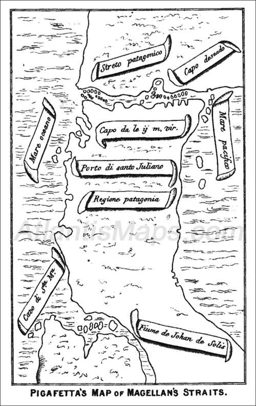
Figure 2 – Pigafetta’s Map of Magellan’s Strait. The map was drawn with a southern orientation which accounts for the Pacific Ocean appearing to the right of the strait.
Pigafetta’s map of the strait strays from his own logged description, opting instead for a very simplified representation which portrays the strait lying horizontal and relatively straight. The closed waterway that Pigafetta described as extending in a southeasterly direction off the strait, he chooses to depict as a very basic U-shaped bay notched and aligned vertically into the strait’s southern shore. Comparing this with Schöner’s 1524 globe it is clear that Schöner was very likely influenced by Pigafetta’s visual depiction of the waterway as he chose a very comparable shaped bay book-ended on both sides by relatively flat coastlines while also mimicking Pigafetta’s concept of a sudden vertical drop beyond the eastern end of the strait (Fig. 3).
Figure 3 – The Strait of Magellan as portrayed on Schöner’s 1524 World Globe (left) alongside Antonio Pigafetta’s map of the strait rotated to a northern orientation. Based on the similarities, it seems likely that Schöner was influenced by Pigafetta’s map. While Schöner adopts a more realistic design for South America, the strait’s southern coast adopts 1) Pigafetta’s simple U-shaped design for the central bay and 2) the coastline’s sudden vertical drop at the eastern end of the strait.
Schöner’s design strays slightly from Pigafetta’s overall design of a horizontal southern coast by angling the bay’s surrounding coastline downward, creating a coastline that more closely resembles Antarctica’s Atka Bay and the surrounding Queen Maud Land. You can see the stunning resemblance this tapered coastline shares with Antarctica as we compare Antarctica with Finé’s 1531 depiction. When these two landforms are oriented similarly with Western Antarctica pointing due west (Fig. 4), Eastern Antarctica’s greater length aligns vertically and in both instances the northern coasts come to a point with the central U-shaped bay representing the northernmost point of the continent.
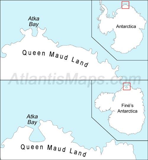
Figure 4 – Atka Bay, Antarctica (top), a U-shaped bay similar to Schöner’s depiction in both look and location. Finé’s map (below) also features the bay. Like Schöner’s depiction, Finé strays from Pigafetta’s flat coastal design in favor of a coast which angles away from the bay on either side, a design which more closely resembles Queen Maud Land, Antarctica.
Schöner 1524 – Scaling Old to New
If Atka Bay and Queen Maud Land, Antarctica can be deemed the primary point matched to Magellan’s newfound strait, then we have confirmed a possible repeat of Steps 1 and 2 of Schöner’s methodology: 1) The referencing of an ancient source map, and 2) The reconciling of the new discovery to the ancient source map via Atka Bay. This leads us to a determination of Step 3, establishing if Schöner referenced a secondary point for scaling and aligning the continent to his globe. On Schöner’s previous maps, the secondary point was the center of Agrippa’s concentric design aligned to the South Pole, but centering a portion of his 1524 map over the South Pole was apparently not an option since the pole sits off center on Schöner’s Eastern Antarctica. This may be a subtle argument undermining to a degree the idea that Schöner was creating his design from scratch, seeing that the pole played such a pivotal role in the design of his previous maps, but was suddenly abandoned and ignored entirely on his most recent. If Schöner were creating this new design from scratch he could have easily centered all or a portion of the continent around the South Pole even doing so by altering the design a bit, after all there would be no harm in making this sort of aesthetic alteration to a design that was entirely a product of his imagination.
There might be the temptation to conclude that the source map identified and marked the South Pole and Schöner aligned the map accordingly, and in fact Hapgood in his book Maps of the Ancient Sea Kings, does conclude exactly that. But there are significant difficulties with this. First the pole is not accurately positioned, although given the accuracy of ancient maps it is not the worst approximation, but more importantly if the source map had somehow marked the location of the South Pole, one would expect other latitudes to have been recognized and delineated as well, but had this been the case Schöner would have had no reason for overscaling the continent.
So if Schöner neither centered any portion of the continental mass over the South Pole nor found the pole marked on his ancient source map to allow alignment of the poles, then we have to look elsewhere for a secondary scaling point, likely a coastal feature such as a peninsula or even a bay like our primary point, Atka Bay.
Yet in reviewing the three main maps which carry this common design of the continent—Schöner’s 1524 globe, Finé’s 1531, and Mercator’s 1538 world map—there is no single shared coastal feature that sets itself apart as a clear secondary scaling point. There is one feature that does offer a bit of intrigue, a pair of small islands that are found on Schöner and Mercator’s maps, but not on Finé’s 1531 map. Finé does include the pair of islands on his 1534 cordiform map designating them deserted islands, but they are aligned vertically whereas Schöner and Mercator align them horizontally. Initially therefore, they do not appear to have any real tangible connection to the continent.
The islands seem to be locked onto the Tropic of Cancer while the renderings of Western Antarctica hover between 200 and 250 miles below the islands on Schöner’s 1524 globe and Finé’s 1534 map, and Mercator’s map distances Western Antarctica twice that at some 500 miles south of the islands. The omission of the islands on one map, realignment on another and varied distancing off the coast of Western Antarctica initially argue against this being associated with the continent and therefore diminishes its potential as a secondary scaling point.
However, due to the fact that these are detached geographical features, it is conceivable that Finé and Mercator chose to omit, realign or separate the islands from the southern landmass without discerning their significance in relation to the continent. If this were the case then Finé and Mercator gave little regard to Schöner’s depictions of the islands and merely referenced Schöner’s continental mass to align and size their maps of the continent. This places the burden of proof squarely on Schöner. If somehow these islands were the key to scaling and aligning the continent then we would expect that Schöner, the man who introduced the world to this overscaled design, would have a very good reason for referencing these islands as the second scaling point. To resolve this we will need to delve into the history surrounding these islands. An inscription placed just below Mercator’s depiction of the mysterious island set provides us the name. The inscription is Latin and reads, “Insulas Infortunatas”: The Unfortunate Islands.
A Tale of Two Islands
November of 1520 found Magellan crying tears of joy as he finally eyed the Pacific Ocean and acknowledged his discovery of the elusive western passage to the orient. In order to reach this historic point, he had barely evaded a Portuguese naval detachment dispatched to seize him and his ships, survived a mutiny aboard two of his five ships, lost one ship, the Santiago, to grounding in a storm, and he was soon to learn that another ship the San Antonio, commanded by his nephew Alvarus Meschito, was also missing. Magellan had overcome the extreme rigors and trials involved in commanding an overly ambitious 16th century expedition into the unknown and the discovery seemed a fitting reward for his valiant effort, but time for jubilation would prove short-lived. In fact a harrowing journey still lie ahead of Magellan and crew as they exited the strait on the 28th of November and continued on their last leg of the journey across the Pacific with the three remaining ships, the Trinidad, Victoria and Concepción.
It was the simplest of plans: Sail northward several hundred miles then proceed westward toward the Moluccus Islands where they would load the ships with valuable spices and supplies and return home via a well-known, well-traveled route where they would report their grand discovery. There was only one problem with this plan, the route from the newfound strait to the Moluccus Islands was new and unfamiliar and Magellan had grossly underestimated its distance and the vastness of the Pacific Ocean, imagining that the Moluccus Islands lay just the other side of the New World. The consequences of this assumption would prove disastrous.
Magellan was so certain of the short distance remaining that he chose not to go ashore and replenish supplies before setting out across the Pacific. Nearly two grueling months after exiting the strait the crew had not sighted any sign of land and food supplies were seriously diminished. On January 24, 1521 they finally discovered land in the form of a small island, but any excitement over the find quickly faded as the island proved to be barren, devoid of human life and food. Only trees and birds populated the small island. They took soundings, but finding no bottom on which to set anchor they continued on their voyage. They named this island San Pablo since it was discovered on the day of Saint Paul’s conversion.
Sailing with a northwest heading, they traveled another 600 to 800 punishing miles before sighting more land, but again it proved to be an island similarly desolate and having no place to drop anchor. They did manage to catch many sharks there and therefore named the island Isle of Tiburones after this particular fish and again continued on their way.
The extent of the crew’s suffering was horrific. Outside of a few days dining on shark meat, the overextended voyage found the crews reduced to eating sawdust and stale biscuit crumbs soiled by rat feces and urine. Ox hide strapping stripped from the rigging was softened in seawater for several days so that the crew could chew and eat this as well. Meanwhile due to a lack of citrus in the diet, most of the crew was suffering from scurvy and their gums swelled to such a painful extent that they were not able to eat. This eventually led to the death of nineteen crewmembers. Dietary deficiencies also lead to twenty-five to thirty cases of rickets, with men’s arms and legs becoming severely disfigured. According to Pigafetta it would not be until the 16th of March, 1521, three months and 16 days since entering the Pacific, before they would find relief, arriving in the Philippines where they were able to replenish their supplies of wood, food and freshwater.
The truly unfortunate circumstance of Magellan’s miscalculation is that it forced him to set a course across the Pacific that swept above and past the hundreds of habitable islands composing Polynesia. Had he known the true size of the Pacific, of course he would have gone ashore and stockpiled supplies before setting out across it, but more importantly there would not have been the need to navigate northward so quickly to reach a latitude near that of the Moluccus Islands. A slower more westerly ascent from the onset would have led him directly through Polynesia where he might have laid claim to a bevy of new habitable islands teeming with food, water and other supplies, instead Magellan chose a course that skimmed just above and in the process discovered only two solitary uninhabitable islands in the whole of the vast Pacific Ocean. Fittingly, the two barren islands having nothing to offer the intrepid sailors but bitter disappointment were unceremoniously dubbed the Unfortunate Islands.
The Magellan Effect
On his 1515 map of the Antarctic continent, Schöner had sifted through a collection of ancient maps armed only with the report of a strait as the singular geographical feature on which to base his selection. Once this match was found Schöner was left with the task of deducing the secondary scaling point himself, settling on the center point of a circular sea. With his 1524 globe, Magellan had provided Schöner two separate and distinct discoveries or two potential scaling points. We have already established Atka Bay, Antarctica as the first scaling point which Schöner fit to Magellan’s newfound strait, but for the Unfortunate Islands to be considered a secondary point and further verify that Schöner was indeed referencing an ancient map of Antarctica, we have to establish that there is a set of matching islands located similarly along the actual Antarctic continent… and there is.
The similarities are extraordinary and a bit uncanny. Nestled along the coast of Western Antarctica and enveloped within the Getz Ice Shelf under layers of ice and snow, there exist two islands, Siple and Carney. There is absolutely no mistaking the marked similarities between these two islands and Schöner’s depiction of the Unfortunate Islands (Fig. 5). And just as Schöner opts for a bay within the Strait of Magellan that more closely resembles Atka Bay than the waterway either described or drawn by Pigafetta, he again ignores Pigafetta’s description and adopts a design for the Unfortunate Islands that more closely resembles Siple and Carney Island in Antarctica.
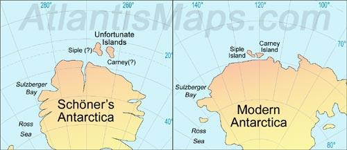
Figure 5 – Schöner’s rendering of the Unfortunate Islands (left) which more closely mimics Carney and Siple Island off the coast of modern Antarctica (right) than conforming to Pigafetta’s description. In both versions not only do the islands align parallel to the flattened far coast of Western Antarctica, they also are positioned right of center.
According to Pigafetta and other varied accounts of the voyage, the Unfortunate Islands were located some 600 to 800 miles apart east to west, and all accounts agree that there was also a separation of 4 to 6 degrees latitude; Pigafetta declares the island of San Pablo to be located at 15 degrees south latitude and the island of Tiburones to be 600 miles west of San Pablo at 9 degrees south latitude. Other 16th century maps like the Hadji Ahmed Map of 1559 (Fig. 6) conform precisely to these parameters while Schöner’s map places the two islands on the same parallel and also disregards the stated 600-mile distance between islands, locating them an extremely insufficient 100 miles apart. The end result being that not only does Schöner provide a respectable portrayal of Siple and Carney as paired islands, but even the channel running between the two islands is relatively accurate in proportion and alignment. Schöner even accurately replicates the two islands’ correlation to the Antarctic continent, placing the islands along and parallel to Western Antarctica’s flattened westernmost coastline while offsetting the pair toward the northern end of the flat where the coastline begins to taper away in the direction of the Weddell Sea. This is all the more compelling considering the uniqueness of a paired, similar sized island set placed in the only place on the continent that they actually exist.
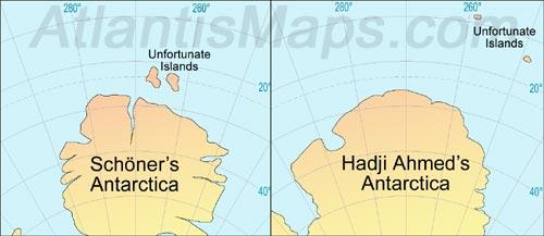
Figure 6 – Hadji Ahmed’s 1559 rendering of the Unfortunate Islands (right) which matches Pigafetta’s description, placing the islands at latitudes of 9° and 15° south while distancing them roughly 600 miles apart east to west. Schöner’s rendering (left) places the islands on a shared parallel at less than 100 miles apart. While Schöner had clearly seen Pigafetta’s map of the strait, he obviously had very little detail on the Unfortunate Islands aside from being located high in the Pacific.
All evidence suggests that Schöner was driven by an ancient chart of Antarctica to place the whole of Western Antarctica far up into the Pacific in order to fit Siple and Carney Island to the approximate location of the Unfortunate Islands while scaling the remainder of the map so that Atka bay could also fit below the tip of South America. This actually sheds light on why Schöner, no doubt aware of the incredible hardships Magellan and his crew suffered on their journey into an immense and vacuous ocean where only two small inhospitable islands were known to exist, would suddenly feel compelled to chart a large landmass sitting a tantalizing one hundred miles south of Magellan’s route. It would seem a cruel joke on his behalf unless he sincerely believed the islands were associated with a nearby landmass. An ancient map of Antarctica with a lone pair of islands lying just off one of its shores would certainly have proved compelling. It should also be considered that if Schöner merely wanted to posit the existence of a landmass beneath the two islands, it really only required appending a landmass to his previous design, instead we find him opting for an entirely new design that takes on a much more conventional design for a landform and conforms to the continent of Antarctica.
Therefore it seems likely that Schöner did indeed have access to an authentic ancient map of Antarctica. Aside from the omission of the Palmer Peninsula and the apparent lack of an ice sheet, between Schöner, Finé and Mercator we not only find accurate portrayals, but also accurate positioning and alignment of Atka Bay, the Weddell Sea, Coats Land, the Ross Sea, Ross Island, Sulzberger Bay, the Executive Committee Mountain Range, Ellsworth Mountains, the Queen Maud Mountains and now, of course, Carney and Siple Island (Fig. 7).
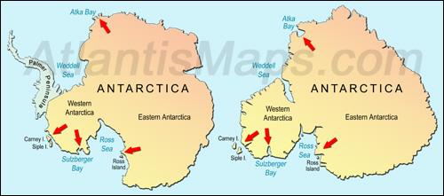
Figure 7 – Side by side comparison of a modern map of Antarctica with the Palmer Peninsula faded out (left) alongside Finé’s map of the continent with Schöner’s Unfortunate Islands added. Besides the amazing similarity in overall shape, the comparison highlights the accurate placement of several detailed components including the scaling points of Atka Bay and the island set of Carney and Siple as well as Sulzberger Bay and Ross Island.
If we accept that Schöner was referencing an ancient map of Antarctica for his 1524 globe, and acknowledge the use of Agrippa’s Orbis Terrarum for his 1515 globe, then we see that the incorporation of both maps comply perfectly to the same logical methodology:
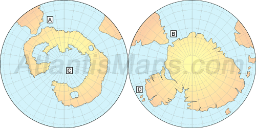
Schöner’s Methodology For Cartographic Incorporation Of New Discoveries
- Referencing ancient maps for his template: Agrippa’s Orbis Terrarum (left) and an ancient map of Antarctica (right),
- Reconciling the ancient maps to new discoveries: (A) Matching the British Channel to a purported strait and (B) Atka Bay to a waterway in the Strait of Magellan, and
- Scaling the maps to new globes via a secondary point: (C) Aligning the center of a concentric Mediterranean to the South Pole and (D) the islands of Carney and Siple to the Unfortunate Islands high in the Pacific.