


For decades archaeologists have argued about the origins of the mysterious “Harappan” (Indus Valley) civilisation that flourished across what is now Pakistan and north-west India from about 3000 BC. Now new findings by Indian scientists working in the Gulf of Cambay suggest that the Harappans were descended from an advanced mother culture that flourished at the end of the last Ice Age and that was submerged by rising sea-levels before history began. Report by BADRINARYAN BADRINARYAN, chief geologist with the scientific team from the National Institute of Ocean Technology (NIOT) responsible for the underwater surveys in the Gulf of Cambay.
It was generally believed that well organized civilizations could not have existed prior to 5500 BP. Many were reluctant to accept that the flood myths mentioned in many ancient religious writings. The recent discovery made in the Gulf of Cambay, India, shocked many and made some to sit up and watch with interest. It clearly established the existence of an ancient civilization that was submerged in the sea. The methodology adopted was novel and different, wherein advanced marine technologies and most modern scientific applications of various disciplines were put to best use. The traditional but conservative archaeologists found it hard to accept that a major discovery could have been made by hitherto unapplied, unheard of techniques. Some observed and understood the importance of the discovery and came out in open support. Initially when the sidescan sonar images of underwater structures were shown, some called it a magic of computer software. When hundreds of artifacts were collected and shown, they opined that it could have been transported by the ancient river! Again detailed scientific studies were undertaken to prove that the artifacts are insitu. The criticism has driven us to adopt most modern technologies and scientific methodologies available in the world which have completely substantiated our findings and the results were published as research papers in reputed international journals. Now several authors are quoting the Gulf of Cambay work as a standard and a bench mark methodology for modern marine archaeological surveys and investigations. The discovery has clearly established the possibility of ancient civilizations that were submerged due to flooding by rising sea waters, after the last ice age.
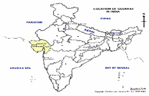
Figure – 1
The oldest civilization of city states is thought to be in Mesapatomia datable to 5500 years BP. An extensive hitherto oldest mature civilization occurs in the North-western part of India adjoining Pakistan and Afganisthan. This is the well-known ‘Harappan’ civilization which lasted between 5300 and 2800 years BP. This includes major ruined cities like Mohanjodaro, Harrappa, Dholavira and villages, craft centers, camp sites, river stations, fortified places, Ports, etc. The cities had well lined streets, arranged in straight line, proper drainage, sanitary arrangements and excellent water conveying systems including check dams for storing water. Usage of variety of artifacts, metallic objects, many types of potteries, construction of huge structures, etc. could not have happened overnight. So obviously there was a major missing link between the ancient hunter gatherer group of people and ‘Harappan’ civilization. In India, there were many Paleolithic, Mesolithic and Neolithic stone-age cultures. But none of them have any remote resemblance of the type of civilization found in the Harappan sites. It is possible that the missing link between the two is either under cover or has been submerged due to major sea level rise caused by melting of ice-sheets. It is a well established fact that during the Last Glacial Maxima (ice-age) the seas all over the world have shrunk and the sea level around 18000 years BP was about 130m below the present day sea level. So, it is logical to look for such submerged civilization near areas surrounding the present day Indian coastal areas especially along the palaeo channel of various rivers.
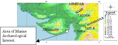
Figure – 2
National Institute of Ocean Technology (NIOT), a Govt. of India undertaking has been carrying out several multi-disciplinary marine surveys along the Indian coastal areas for various purposes. During the course of few geological surveys in Gujarat (Fig.1) in the Gulf of Cambay, (Fig.2), NIOT came across palaeo river channels in the sea. These were seen to be the extension of the present day major rivers of the area.
In a similar marine survey, in a Coastal Research Ship during 1999-2000 when the author was the Chief Scientist, several unusual frames of Side Scan Sonar images were encountered. These had square and rectangular features in an arranged geometric fashion which are not expected in the marine domain. Such features are unlikely to be due to natural marine geological processes. This made the author suspect that human workmanship must have been involved here. The surveys were followed up by the author in the following years and a couple of palaeo channels of old rivers were discovered (Fig. 3 &4) in the middle of the Cambay area under 20-40m water depths, at a distance of about 20 kms from the present day coast.
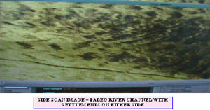
Figure – 3
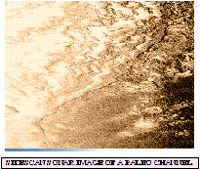
Figure – 4
The Gulf of Cambay forms a funnel shaped entrant of the Arabian Sea sandwitched between the mainland Gujarat and Saurashtra Penninsula in the west. This gulf is 135 km long in a N-S direction and is more than 100km at its widest part. It is one of the roughest and most complicated seas of the world and covers an area of about 3000 sq.km. Several major rivers including the Narmada, Tapi, Sabarmathi, Mahi, Chathranji, etc. drain into it. It has a macro tidal range of 12m and the currents are up to 8 knots. The sea is often subjected to severe winds resulting in very rough conditions. These types of turbulence churn the seabed and produce enormous quantities of silt, making the sea water brownish and turbid, with the result that is that it is impervious to light rays. The combined effect of these conditions makes this part of the country unfit for diving and underwater operations and operating underwater videography impossible. Hence, only instruments operated on principle of sound, like sonar equipments and magnetic equipments could work here. This includes the Side Scan Sonar, Sub-bottom Profiler, Multibeam ecosounder, apart from marine magneto-meter.
The term SONAR stands for Sound Navigation and Ranging. Sonar is a sensing stratergy which measures features of an environment (or medium) by the way in which that environment transmits, reflects and/or absorbs acoustic (sound) waves. The seabed is a little understood environment due to its inaccessibility and resistance to large scale detailed analysis. Sonar represents a clear approach of looking at the seafloor. Side Scan
Sonar uses sound waves to produce images of the seafloor. The hard areas reflect more energy and are seen as dark shades, whereas softer areas do not reflect energy as well and are represented by lighter shades. This “Backscatter” is absent behind objects or features that rise above the seafloor, and are represented as white shadows in the sonar image. The dimensions of shadows are used to infer the size of the objects. The system used was a digital one which provides high resolution sonar images of the seafloor through advanced digital technology in 100 and 400 kHz frequency. The unit is connected to a Differencial Global Positioning System (DGPS) for the accurate position of the survey vessel and in turn that of the objects.
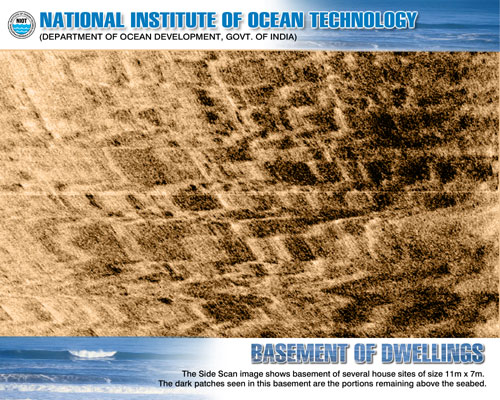
Figure – 5
In these surveys it was the SideScan Sonar which gave excellent results supported by other systems. Initially two major palaeo channels of rivers were recognized. One over a length of 9.2km and another over 9.0km. When these were sampled, it was seen that just below a thin marine sediment cover of few centimeters, river alluvium and pebbles typical of terrestrial river sediments, below which typical river conglomerates were observed at depth. Such evidence clearly indicated that the area presently under sea, was originally dry land over which rivers were flowing. Due to different factors, they got submerged and now lie beneath the sea. The sonar images showed regular geometric patterns in one palaeo channel over a length of 9km in the sea about 20km west of Hazira coastal area. Associated with this on either side of the palaeo channel , basement like features in a grid pattern were observed at a water depth of 20-40m. These resemble an urban habitation site wherein, in the basement now at the bottom of the sea, pit like structures are seen. Another palaeo channel over 9.2km was detected off Suvali coastal area. Here also similar features were observed. In general the basement like features were located in a linear east-west direction on either side of the palaeo channel. It is seen that these features are 5x4m size on the eastern side whereas the westernmost part had dimensions of 16 x 15m. The habitation sites are all seen to be laid in a strict grid like pattern (Fig.5) indicating a good sense of town planning by the ancients.

Figure – 6
There were also evidences of water conducting system like canals, etc. All these point to a properly planned township, with a high level of knowledge and practice by the ancients. The area in general is seen to be covered by sand waves which occur above the seabed. Often these cover the dwelling but even then the shapes could be made out (Fig.6). Apart from the regular sites of habitation, the Side Scan Sonar picked up images of several big structures. Some of these structures are as follows :
There is a rectangular (41m x25m) shaped depression, wherein one can sea steps gradually going down to reach a depth of about 7m (Fig.7). Surrounding this depression there is a wall like projection on all sites. One could observe an inlet and outlet and also a separate enclosure. This looks like a tank or bathing facility now occurring below 40m of sea water. It occurs near the western periphery of the town. It resembles the “Great Bath” that is found in the ruins of “Mohonjadaro” and “Harappa”, where also these occur on the western side of the township. There are two divisions in the tank, which may represent separate enclosures for men and women or for socially higher and lower categories of people. There are two openings probably for inlet and exit of water to keep the water in the tank fresh and clean.
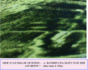
Figure – 7
In Fig.8 one could observe a long linear prominent and well made basement of a major structure measuring 200m x 45m. It nestles on high ground and one can see steps on the right corner approaching the structure. Inside the structure there are many 18m and above square shaped room like features with fortifications surrounding it. This type of huge structures resembles the “CITADAL” found in Mohanjodaro, Harrappa, Dholavira wherein these occur at the western extremity again on the high ground. Probably it is an administrative building supervising the entire civic activities of the township or could be a place of worship. Some pieces of fossilized human bones, natural teeth and
some fossilized animal bones were recovered during sampling on the eastern side of the citadel

Figure – 8
Sonar image in Fig.9 picked up a major dilapidated structure measuring 190m x 85m with spaces separated by what looks like collapsed walls. In front of it, on the bottom side there are several basements of rectangular shaped 2.5 to 3.5m x 6m structures, resembling minor dwellings. It could be an ancient granary for the township probably with dwelling place nearby, for the workers. In the nearby areas some fossilized food grains have been collected. In many of the Harappan sites the granary is a regular feature.
The image in Fig.10 is that of a basement of a buried settlement and it measures 74m x 48m. It has regular square, rectangular and arch shapes. The darker portions are the elevated or standout features. These indicate that there are still some constructed portions standing up partly. To the north of the structure also, a few square and rectangular shaped basements are visible.
A buried structural basement is depicted in Fig.11. The main structure measures 40m x 19m with wall-like dark features rising to 2-3m above the seabed. A series of step-like features are seen approaching the structure from the right side. To one corner of the main structure a 11m x 7m rectangular depression looking like a small tank or pond is observed.
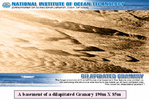
Figure – 9
Sub-bottom profiler surveys, instead of reflecting sound waves from the seabed like side scan sonar, penetrate the seabed. The waves travel beneath the seabed in different formations in different speeds and the instrument collects the reflection data over selected frequencies. It provides good depth information on geological features apart from delineating any suspected buried anthropogenic structures.
The sub-bottom profiler image in Fig.12 is below the 200m x 45m Citadel like structure. The standout features were picked up at regular intervals and appear to be the basement and foundations of the structure. It is observed that the foundations have been dug up to 5-6m in the soil over which broad column like features have been constructed, probably to take the load of the huge structure above.
The sub-bottom profiler image in Fig.13 is below the buried settlement of 74 x 48m structure. Here also man made foundations like column can be clearly seen emerging from below the seabed and occur as standout features. Here, the foundations have been dug up to 3-4 m deep in the soil. These types of planning and method of construction by ancients clearly reveal that they had a very good knowledge of civil and structural engineering, wherein broader and deeper foundations were provided for bigger and heavier structures and thinner and shallow foundations for comparatively smaller structures. Likewise almost all the structures including the dwelling sites indicate a good amount of planning and design, taking into consideration the structural aspects.
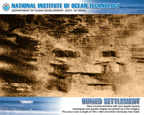
Figure – 10
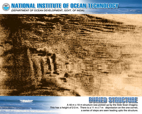
Figure – 11
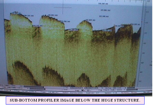
Figure – 12
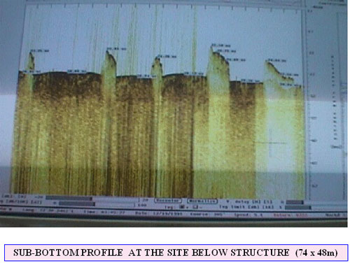
Figure – 13
Magnetic surveys were carried out by deploying a high resolution Marine Ceisium vapour Magnetometer. The survey was for observing magnetic signature occurring as anamolies of subsurface magnetic bodies of the area. The instrument was capable of sensing upto 0.001 nT at 1 sample rate. The values here were corrected for diurnal variation so as to remove the temporal variation in the earth’s magnetic field. The corrected magnetic field value is a result of the marine magnetic components :- regional geological features are very deep seated in origin and have depth persistence whereas one should look for very shallow and near seabed anaomolies that do not extend in depth. Several shallow near surface anomalies were picked up ranging in depth from 1m below surface to as much as 50m. The deep seated anomalies are atleast below 400m from the seabed surface. The near surface anomalies in general are covered by top sediments and are likely to be archaeological sites which are to be examined and explored later. Due to these surveys a vast area has now acquired importance for archaeological purposes – including areas that were earlier not picked up by sidescan images. As such these surveys enhance the area of archaeological interest. Obviously this was an extensive civilization, the remains and ruins of which have since been covered by shifting shoals, sandwaves, tectonism etc., which are very common features in the Gulf of Cambay.
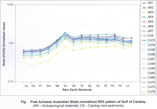
Figure – 14
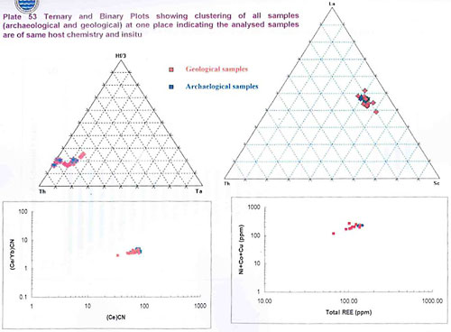
Figure – 15
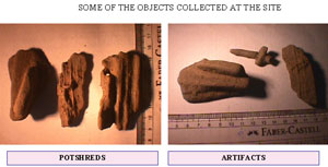
Figure – 16
Even though a variety of objects and artifacts were collected in settlements, doubts were expressed by some persons whether these could have been transported by paleochannel and may not be insitu. To clear such doubts detailed geochemical analysis were carried out. Ten geological soil samples and ten artifacts were chosen from the Gulf of Cambay area. Since trace elements like Ti, Hf, Th, etc and Rare Earth Elements (REE) are immobile they preserve their signature without alteration and hence reflect primary petrogenic character. These 20 selected representative samples were analysed using ICP-Mass spectrometer. The rare earth element pattern normalized with shale are given in figure 14 & 15. The results of the analysis clearly reveal that there is one to one match between the archaeological material and Cambay bed sediments. This is characterized by leaching of light rare earth elements and a prominent Europeam anamoly .The ternary and Binary plots of both the materials show clustering of all samples in one place indicating the samples are of same host chemistry and are insitu i.e. that the archaeological material are not transported but are made from locally available material only.
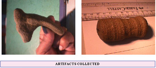
Figure – 17
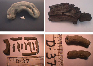
Figure – 18
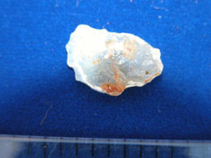
Sampling : In order to substantiate the findings detailed sampling was carried out. Since the sea condition was very rough and the water turbid and brown, sampling was carried out in areas where side scan images show excellent results. The samples were collected by utilizing a grab sampler, dredger, gravity corer and vibro corer. Large numbers of samples were carefully collected, systematically numbered and properly preserved. The artifacts collected included a variety of pottery pieces, Mesolithic stone tools, a few Paleolithic macro stone tools, beads made of semiprecious stones, brick pieces, hearth material, wattle and daub structure materials, corals, perfectly holed stones,, fossilized human remains and human teeth. Fig.16 has three potsherd pieces. These are unfired and normally sun-dried, made of clay and of great antiquity. On the other side of the figure a cross like object and some figurines are seen. Fig.17 shows the shape of deer’s head and to the right a well turned ornamental piece with a straight hole in the center. How the ancients were able to make them in stone is still an enigma.
In Fig.18 there are four very important objects. First, one can observe a fossilized jaw bone (mandible) with a natural tooth kept in front. Next to it is a part of the carbonized wooden log. This was obtained from the top stratigraphic colomn at a depth about 30 to 40cm below the seabed and it was sent for dating. In the left corner there are rolled objects and long linear beads which when strung together forms a necklace. In the right hand bottom of the figure linear beads made of stone are there with holes in the middle.
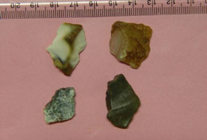
A series of microlithic tools were collected at various locations. Generally microlithic tools are characteristic of the Mesolithic period and are found between Paleolithic and Neolithic stone age periods. The characteristic features of mesolithic tools are that unlike the earlier Paleolithic stone tools these are much smaller, normally between 5cm to 1cm in length and are made of finely crafted semi-precious stones. These include quartz, chert, jasper, flint, chalcedony, agate, corundum, etc. About 248 such tools were collected by sampling. The tools included a baked blade with a serrated edge, point, point on flakes, lunate, scraper, cores with negative chipping and a borer. The tools have both geometric and non-geometric forms.
The Mesolithic period of Western India revealed the existence of their cultural phases, namely aceramic and ceramic. In general the Mesolithic sites confirmed the existence of a ceramic phase in its later part, containing other than potteries and microlithic tools, materials like wattle and clay shreds for house construction, flooring of the houses, etc. The Mesolithic sites are comparatively larger. Here the hunting and gathering way of life was replaced by organised food production. Holed stones which appeared in the late paleolithic became prominent in the Mesolithic. These holed stones appear to have been used as weights in digging sticks and as net sinkers by the fishing folks. In general a sedentary form of living heralded the beginning of other associated cultural artifacts like pottery, living in well-built houses like wattle and clay, or of sun dried and fired bricks.
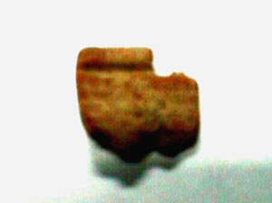
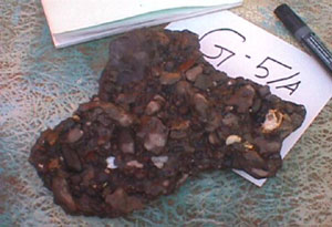
Coming to microliothic tools a variety of classic collections were made. These include Thumb nail scraper (Fig.19) to skin the small animals (Fig.20), obliquely truncated fluted core made of red corundum apart from borers and points (Fig.21). Usage of Corundum is something unique as it is the second hardest material known after diamond as per the Mohrs scale of hardness. The red and blue transparent varieties of corundum are the gem stones Ruby and Sapphire.. This is the first reported usage of corundum as microlithic tool in India and maybe in the world. Other tools include a microlithic blade made of chert and quartz (Fig.22) for cutting purposes, a microlithic side scraper (Fig.23), and a microlithic tool point with a serrated edge (Fig.24). Apart from these, pieces of hearth material have been collected (Fig.25). These were used for firing and heating and hence are very good for dating purposes. At places pieces of light weight, hollow circle-like materials have been collected (Fig.26). Probably these may be slag pieces, cinder after extraction of metal, and the ancients might have the knowledge of some metallurgy. Pottery pieces of various types have been collected. These include a broken bowl (Fig.27), coarse red-ware (Fig.28), pottery pieces embedded in mud walls (Fig.29), slow wheel turned pottery pieces (Fig.30), pieces of jar-lid (Fig.31), pottery piece with some cord impression (Fig.32) and a very ancient fragment of pottery, possibly amongst the oldest so far collected anywhere anywhere in the world. (Fig.33)
 Thumb Nail Scraper Figure – 19 |
 Microlithic tools Figure – 20 |
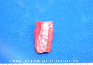 Figure – 21 |
 Figure – 22 |
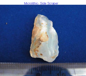 Figure – 23 |
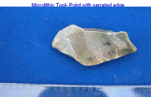 Figure – 24 |
 Hearth Material Figure – 25 |
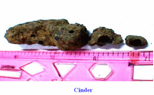 Figure – 26 |
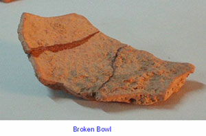 Figure – 27 |
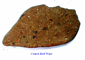 Figure – 28 |
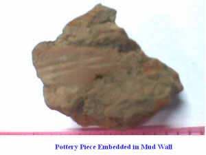 Figure – 29 |
 Pottery Piece Figure – 30 |
 Jar Lid Figure – 31 |
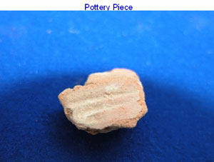 Figure – 32 |
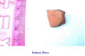
Figure – 33
Even though most of the artifacts are of Mesolithic period, there were some Paleolithic tools which were much older. It shows that people have been living in the Cambay area for quite some time. One example is the bifacial scrapper, made of chert and a very characteristic upper Paleolithic stone tool (Fig.36). Similar stone tools were also present but many of them due to long submergence and rolling in the seabed appear to have their edges smoothened out and the sharpness of the edges is rather less.
River Conglomerate
Figure – 34
A thorough examination of the macro and micro levels of soils in Gulf of Cambay brought to light a wealth of plant material typical of the land domain. Extensive studies are being carried out by a Botany Professor and the studies may initiate a new branch in Marine Archaeology which may be called as Marine Archaeo Botony. So far prominent plant species identified include palm, coconut, bamboo, areca plant, etc. Many of them are fossilized. Some of the species identified and photographed are as follows (Fig.35). The top left show fossilized food grains, in top right one could observe the inner portion of a bamboo plant. In the bottom left, plant fiber material could be clearly seen and at bottom right one could see palm leaf with typical ridges. All these were recognized under the microscope.The major wooden log a part of which is shown in Fig.18, when taken out of the seabed was very fresh, dark, hard and showing growth rings, etc. Within a couple of days of exposure to the atmosphere the wooden log completely shrunk and developed cracks. It has given important date for the area. This species has been tentatively identified as belonging to hard wood like rosewood. All these point to well grown trees and foliage with lot of good fresh water and somewhat warm climate, at the time of their growth in the area.

Bi-Facial Scraper-Upper Palaeolithic
Figure – 36
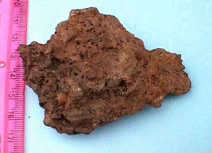
The palaeo channel below the alluvium has hard dark alluvium and then typical river conglomerate (Fig.34). It clearly indicated fresh waters alluvial environment. Several insitu pieces of alluvium and conglomorate have been collected. All these factors clearly establish that the palaeochannels were originally well-flowing rivers in the land, which were subsequently submerged by the sea.
Since some persons have expressed doubts about the pottery pieces, a thorough scientific study was made involving the pottery pieces to establish their authenticity. To determine the properties of various material including pottery, many samples were subjected to X-Ray diffraction (XRD) analysis. Since the materials that constitute pottery etc are clays and heterogeneous mixures of a variety of materials, these were accordingly analysed. Every area has a special fingerprint pattern in the clay which can be recognized in X-Ray diffraction (XRD). The above analysis was carried out in Deccan College, Pune Maharashtra state, India,by using an advanced instrument which gave excellent results. The conclusions are that the pattern of pottery pieces corresponds very well with the locally available clay of gulf of Cambay. The mineral patterns of habitational floor, wattle and daub and land materials (alluvial deposit) are comparable. The patterns of fired clay, floor birck piece, vitrified clay, compare very well. All these indicate that they are genuine artifacts, made from locally available material and are insitu. It fully confirms the presence of archaeological sites. The findings indicate that the pottery was produced locally with levigated clay, fired uniformly at about 700oC. From the presence of calcite in clays and pottery arid to semi-arid environmental conditions prior to the submergence of the site could be deduced. Calcritised alluvial deposits indicate the existence of ancient rivers which once flowed in the submerged regions of Gulf of Cambay.
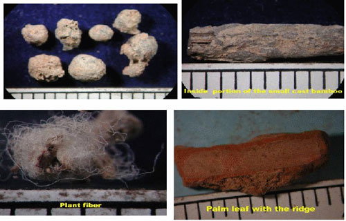
Figure – 35
Dating of samples : Most of the structures that were discovered in the Gulf of Cambay had many similarities to the CITADEL, GREAT BATH and grid-iron pattern habitation sites grannery, etc. of the Harappan civilization. But many of the artifacts and typology were very different and distinctive and with the presence of so many micro tools appeared to be much older than the Harappan. In order to establish the credibility and age of the civilization it was essential to date different objects and artifacts to establish the period of the Cambay civilization. There are many types of dating of archaeological artifacts like carbon dating, Thermoluminesence, OSL, AMS, Dendrochronoly archaeomagnetism, Electron Spin Resonence dating, Pottasium-Argon dating, Cation Ratio dating, etc. In all about 23 numbers datable objects were selected covering both the palaeochannels. From the samples obtained from the marine archaeological sites it was clear that the following methods will be most suitable and a fairly accurate age determination can be obtained from them. These are 14C radiocarbon dating, radio carbon dating by Accelerator Mass Spectrometer, Thermoluminescence and Optically stimulated luminescence.
Radio carbon dating is a method for obtaining age estimates on organic material and is effective from the present back to a maximum of 50,000 BP. Radio active carbon 14C produced in atmosphere is absorbed by plants and the radio active carbon enters the human and animal cycle when the plants are eaten by animal and human beings. The absorbing of 14C is stopped when a living organism dies and 14C starts to disintegrate.. How much 14C is disintegrated and how much is left out can be measured and the rate at which it disintegrates is known. From this the age of organic objects like trees, corals, human remains, shells etc.can be determined. For age determination tests about 50-100 gms of organic material is necessary. In the AMS, an organic sample much smaller of the order of 1 to 2 mgs is enough to calculate the age. This has several advantages over the regular 14C method.The TL method is mainly used for rocks, soil materials, pottery, etc. that were fired. It is based on the principle that almost all natural minerals are thermoluminescnt. Energy absorbed from ionizing radiation frees electrons which are trapped. Later heating releases the trapped electrons producing light. Measurement of the intensity of the light can be used to determine how much time has passed since the last time the object was heated. Natural radioactivity causes TL to build up so that older an object more light is produced. Since a certain amount of heating, generally up to 350 deg.C, is required TL works best for ceramics, cooking hearths, fired bricks, fire cracked rocks or fire treated minerals such as flint or chert.
The OSL is similar to Thermal dating. The mineral in the sediment grains are sensitive to light and when exposed to light the electrons vacate the sediment grains. This process is called recombination or clock setting event. To detect the age the comparision must be made between sediment grain with a known amount of added radiation and sediment grains that are acted upon naturally. This method is suitable for a variety of unheated sediments not older than 500,000 years. This includes silty and sandy sediments that are deposited by water.
The selected samples for various types of dating were sent to some reputed institutes in India, Oxford University, England and to Hannover Germany. Some samples were repeated in different institutes to get confirmation of the age. The results tallied very well. The datable objects were selected to represent both the palaeo channels. However comparitively fewer datable samples were obtained from the southern palaeo channel. In the northern palaeo channel alluvial samples were collected at different depths to have an idea about the age of alluvium as well as the river. Of the total 23 samples that were dated 14C method was followed in 4 samples, TL method in 6 samples and OSL in 13 samples ages were determined.
The alluvium samples of northern palaeochannel were tested at the behest of NIOT by Manipur University. The top alluvium collected just below marine sediment was dated to be around 3000 BP and a slightly lower alluvium gave an age of about 5000 BP. A black alluvium which was somewhat semi consolidated and collected above the river conglomerate gave an age of 19000 BP. Obviously the river has been flowing at least between 19000 years BP, prior to Glacial Maxima and up to 3000 BP. This shows that the palaeo channel in the north was active and a riverine regime existed at least from about 19000 BP. As the area and the palaeo channel to the south was proven to be a hydrocarbon rich zone, several oil and gas producing wells and platforms have been put along with Xmas trees and several oil and gas pipeline are crisscrossing the area. Due to these factors no further sampling than the preliminary one could be undertaken in view of the safety and restrictions in the oil production areas. The water depths of the alluvial samples collected in the northern palaeo channel varied from 20 to 32m.
In the southern township or palaeochannel area six samples suitable for dating were identified. Of these 3 are carbonized wooden samples, one was a sediment sample, one was a fired pottery piece and one hearth material. Sample from the same carbonized wood was sent to National Geophysical Research Institute, Hyderabad, India and Geowissenschaftlicte Gemeinschaftsaulguben, Hannover, Germany for Carbon dating. This was the first sample (Location 21o 03.08’ N ; 72 o30.83 E) from near the southern palaeochannel. This first gave a clue to the age and environment of the civilization. The calibrated age as per NGRI was 9580-9190 BP and as per Hannover Institute it was 9545-9490 BP. It means the age is about 9500 BP and this takes the age by more than 4000 years older than the oldest city civilization of Mesopotomia and a fore-runner to ‘Harappan’ civilization. But this occurred near the top of the stratigraphic coloumn. Because of this it was expected that at the lower levels age will be much older and make the civilization really an ancient one. The wooden piece tested at Birpal Sani Institute at Lucknow, U.P. state gave a calibrated age of 8450 BP. However, two important artifacts were obtained in the near by area at lower levels. These were a nice, thin, pottery and a brownish to red hearth material. Along with it a local clay sediment was also chosen. All the three samples were analysed in the Physical Research Laboratory, Ahmadabad, Gujarat State, using standard Thermoluminescence based pottery dating techniques. As expected the one of the pottery piece whose figure is given, gave a date of 13000 ± 1950 BP. It is an important date. Another pottery piece which was ill-fired, on OSL dating (Location 21 o12.54’ N ; 72 o 30.370’ E) by Oxford University gave an age of 16840 ± 2620 BP. These are the oldest fired pottery pieces obtained sofar in the world. Till the results were out it was from Japan where the oldest potteries were known. The “Jomon” Pottery from the Fukui cave in Kyushu gave 12000 BP uncalibrated age. The pottery findings from Odai Yamamoto gave uncalibrated age of 13500-13800 BP. In the Gulf of cambay civilization already attempts appear to have been made in experimental pottery making. These are seen from effects of fired clays (for making pottery) which gave ages of 20130 ± 2170 BP (Location 21 o 13.720’ N ; 72 o 26.190’ E) and 16600 ± 1150 BP (Location 21 o13.80 ‘N ; 72 o 26.10 E), by OSL as determined by the Oxford University dating lab. The well fired 3 potteries in the northern palaeochannel gave ages of 7506 ± 785 BP, 6097 ± 611 BP (both by Manipur University) and 4330 ± 1330 BP by Oxford University.
Apart from this sun-dried Pottery pieces were collected in these areas. Three of the specimens were dated by OSL facility in Oxford. The results obtained are (1) 31270±2050 BP, (2) 25700±2790 BP and (3) 24590±2390 BP. A black slipped dish which was also sun dried was dated in Oxford by OSL. This gave an age of 26710 ± 1950 BP.
The hearth material from the southern township (Location 21o03.04 N 72o30.70 E) by TL dating from PRL, Ahmedabad gave an age of 10000 ± 1500 BP whereas the hearth material near the top in the northern township gave an age of 3530 ± 330 BP by OSL, Oxford University. One of the charcoal pieces obtained on the northern side was tested by 14C dating in BSIP, Lucknow. It gave calibrated age of 3000 BP. It tallies very well with the age of upper most alluvium in northern Palaeochannel.
The wattle and daub materials which were originally of wood and clay were seen to be burnt but the structure of the wood was well preserved at places (being fossilized). These were tested by OSL at Oxford and by TL at Manipur from the same locations. OSL dating found it to be 5860 ± 720 BP and TL dating determined it to be 5530 ±550 BP. They appear to be a comparatively good match and they reflect the proper ages. They may represent the period at which these structures caught fire.
From the above it is quite clear that the human activity is very evident from about 31000 BP in what is now in the Gulf of Cambay much before the Glacial Maxima at 18000 BP. The ancients were making potteries and were getting them dried initially in the sun. From about 20000 years, it is clear that the ancients are firing the clay to produce pottery. That means they knew how to make, maintain and manage fire. They appear to have succeeded in making fired pottery from about 16800 BP. They knew the art of construction of towns and houses in neat straight line, row after row as picked up by Side Scan Sonar image and wattle and daub structure and from rammed floor. Both the northern and southern townships have continuous habitational sites interspersed with big structures in between. But good quality fired pottery makes it appearance from about 13000 BP. In the southern township (we can call them metropolis) there appears to be organized activity in the form of a community living, a granary (where fossilized food grains were collected) , etc., from about 13000 BP. To the south of this township in the Gulf of Cambay, sidescan Sonar picked up a drowned dead coral colony of 400m long and about 200m wide in a water depths of about 40m substantiated later by sampling. It is a well known fact that these corals live in hardly 2 to 3m water depth very near coastal areas. They require clean environment and good sunlight. Obviously the southern metropolis appears to have been near a sea coast at a particular point of time, when the metropolis itself stood on dry land with a good free flowing river and was a major bustling city. The dating of coral colony like other places by drill core will provide the date of beginning of coral build up in the area and the top sample of coral will reveal the age at which it was drowned giving a direct clue to the drowning of southern metropolis. It is worthwhile noting that the datable objects are found has only up to 8450 BP based on the date of the carbonized wood.
The northern metropolis has well made pottery pieces, wattle daub etc. from about 7506 BP onwards. It indicates well organized city living. Hence it is possible that this metropolis came up after 8450 but much before 7506 BP, may be after the submergence of the southern metropolis. The ancients appear to have shifted and founded the northern metropolis. However the various earlier dates from sun-dried pots etc. indicate that it was under constant habitation.
Evidence from Microlithic tools :
Apart from palaeolithic macro tools several pieces of micro tools have been collected. Usage of such tools have been reported in America, Europe and other places. In south America especially from Brazil presence of human beings are reported from 14000 BP, coinciding with big Pleistocene mammals. The study there indicated that between 17000 and 7000 BP most coastal plains have been lost due to sea level rise. Several microlithic tools which were recovered are seen to occur from 10970 BP. But the lagoa santa people occupying these areas in Brazil suddenly disappeared between 8000 and 7000 BP. In Europe in France, Germany, Belgium etc. the microlithic tool period started from 11800 BP taking back the age of the Mesolithic period. The microlithic period spread to several areas and lasted up to the seventh millennium BP.
In the Gulf of Cambay a variety of microlithic tools have been obtained in continuation of late palaeolithic tools. The presence of highly evolved experimental pottery from 13000 BP, organized living, sedentary well planned habitation, advanced sanitary and town planning activities in the southern metropolis indicates that it had developed to be a established civilization from about 13000 BP. Already there were evidences for control of fire, making pottery etc. from about 16840 BP. The southern metropolis so far has provided datable objects up to 8500 BP. The well developed northern metropolis has dates of civilization from about 7506 BP. In this one should take into consideration the ideas given by Graham Hancock who also postulated that several cultures in near coastal areas have been flooded and submerged by rising sea level caused by melting of icecap subsequent to the last iceage. The inundation maps prepared by Dr.Glen Milne of Durham University, England clearly shows that the Gulf of cambay area prior to 7600 BP was mostly land and after 6900 BP it is mostly submerged. This type of rise in sea level is very much supported by the work of Dr.P.K.Banerjee pertaining to southeast coast of Indi, work of Sahidul Islam and Tooly in the Bay of Bengal in Bangladesh and Sen and Banerji’s work near Calcutta.
The area is highly prone to severe seismicity. In the past 500 years several earthquakes have shaken area, including the major +8 magnitude Richter scale event on 26.1.2001. On 16.1.1819 an 8.3 magnitude event devastated several areas nearby. It is seen that these quakes cause lot of subsidence at places and elevation at other places.
In the Gulf of Cambay itself various surveys have picked up fault zones and earthquake affected areas with throws upto as much as 30m (elevation and depression). The Gulf of Cambay was formed by a major rift. In order to understand the phenomenon and paleo-seismic activity, NIOT, commissioned Dr.Rajendran of CESS, Trivandram to carry out Paleo-seismic studies in the area surrounding Gulf of Cambay. His path-breaking work of identifying paleo-seismic events and dating them with OSL and also dating nearby Organic material has given excellent evidence to support the findings. He could detect the presence of sand blow layers caused due to old earthquakes as well as new ones. His work in peripheral land areas of the Gulf of Cambay like Kathana, Lotal and Motibaur gave evidences of major earthquakes in the Cambay areas in the following period (1) 2780 ± 150 years BP, (2) 3983 ± 150 BP and (3) 7540 ± 130 BP. Herein lies the evidence of the end of the Gulf of Cambay civilization. In the old major event about 7600 or near about the southern metropolis appear to have been thrown down by faulting and the nearby sea appear to have inundated it. Because of this the people appear to have proceeded north in the elevation higher than the sea level and established the 2nd or northern metropolis. This also got affected by faulting due to earth quakes around 4000 BP and destroyed by the 2780 ± 150 BP EQ, by down throwing the metropolis and sea transgressed the area to completely submerge it.
In this connection it is worthwhile pointing it out three important aspects:
The folk songs in local Kachchi dialogue, mention about 4 major towns of ancient past. Three of these have been identified as Mohenjadaro, Harappa and Dholavira. Obviously the fourth one and the biggest of them all and oldest is the Gulf of Cambay metropolis. )
The 2nd aspect is work by other agencies describing small-scale stone ruins near the Gulf of Kuutch, at the present-day town of Dwarka, as the remains of the ancient, fabled city of Dwarka – so well described as the abode of Lord Krishna of Mahabarata fame. The city is said to have been completely transgressed by the sea and this is vividly described by Arjuna, Krishna’s main disciple in the “Mahabaratha Epic”. The puzzling aspect which is incoherent is the location of city of Dwaraka. The temple we see today is hardly 900 years old. The area all around is dry, void of vegetation, and with brackish water. Krishna is supposed to have maintained a huge army of men, animals like Elephants, Horses, etc. There are absolutely there are no trees or foliage or fresh water for a big army. So it strikes a discordant note about the location. But the submerged metropolis of the Gulf of Cambay has strong, powerful flowing rivers, lots of trees and foliage and huge township of truly ancient times. So probably the metropolis in the Gulf of Cambay could be the “Dwaraka City” of Mahabarata fame.
The third aspect is to consider what happened when the first and second metropolis got submerged. It is interesting to note that there are about 500 Harappan and pre-harappan settlements in Gujarat of which about 258 are on the peripheral areas of Gulf of Cambay. All of them are younger than the Gulf of Cambay metropolis (southern). To the immediate west of the Gulf of Cambay on the Saurashtra coast is the well known pre-Harappan and Harappan archaeological site of Padri. It has been established by the Deccan College researchers, that the river Chatranji which is now flowing east into the Gulf of Cambay, originally flowed west but was tilted towards the east by large-scale structural changes. By connecting it to the southern palaeo channel and extending it, it is seen that it goes to Prabhaspatten in the Arabian sea, and Prabhaspatten is a well known pre-harappan archaeological site mentioned in the Mahabharata epic. To the east the Palaeochannel is seen to be an extension of the present day river Tapi. Obviously the river Tapi was flowing right up to Prabhaspattan on the Arabian sea prior to the drifting and formation of the Gulf of Cambay. It now falls into the Gulf of Cambay instead of the Arabian sea. The ancients after the catastrophe and submergence in the Gulf of Cambay appear to have spread out all over Gujarat and then to the surrounding areas to establish a continuing and evolving civilization of Harappan type.
So, from the foregoing it is very evident the prehistoric civilization that matured and developed in the present day Gulf of Cambay was the forerunner and model to the subsequent advanced Harrapan civilization known to history. This wonderful twin prehistoric metropolis of Cambay lasted from about 13000 BP to about 3000 BP making it the most ancient and largest city civilization not only in Asia but in the entire world. It is seen to be at least 7500 years older than the oldest Mesopotamian city civilization. However strong evidence supports the presence of humans from at least 31000 BP who were evolving and developing and formed a great hitherto unknown civilization that were submerged by the flood, giving credence to local and global flood myths.